
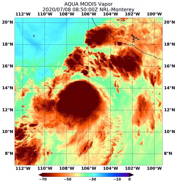
IMAGE: On July 8 at 4:50 a.m. EDT (0850 UTC) NASA’s Aqua satellite passed over Tropical Cyclone Cristina, located in the Eastern Pacific Ocean. Aqua found highest concentrations of water vapor…
view more
Credit: Credits: NASA/NRL
When NASA’s Aqua satellite passed over Tropical Storm Cristina in the Eastern Pacific Ocean on July 8, it gathered water vapor data that provided information about the intensity of the storm.
NASA’s Aqua satellite passed over Christina at 4:50 a.m. EDT (0850 UTC) and the Moderate Resolution Imaging Spectroradiometer or MODIS instrument gathered water vapor content and temperature information. The MODIS image showed highest concentrations of water vapor and coldest cloud top temperatures were around the center of circulation. MODIS data also showed coldest cloud top temperatures were as cold as or colder than minus 70 degrees Fahrenheit (minus 56.6 degrees Celsius) in those storms. Storms with cloud top temperatures that cold have the capability to produce heavy rainfall.
Water vapor analysis of tropical cyclones tells forecasters how much potential a storm has to develop. Water vapor releases latent heat as it condenses into liquid. That liquid becomes clouds and thunderstorms that make up a tropical cyclone. Temperature is important when trying to understand how strong storms can be. The higher the cloud tops, the colder and the stronger the storms.
The National Hurricane Center noted that satellite images show that the convective organization of Cristina is gradually improving, while bands of thunderstorms are developing across the northern portion of the circulation. The center of Cristina’s circulation was still under the northeastern side of the main area of convection due to moderate vertical wind shear, but that wind shear appears to be diminishing.
On July 8 at 11 a.m. EDT (1500 UTC), the center of Tropical Storm Cristina was located near latitude 14.6 degrees north and longitude 106.9 degrees west. That is about 350 miles (560 km) south-southwest of Manzanillo, Mexico.
Cristina is moving toward the northwest near 12 mph (19 kph). A turn to the west-northwest is expected by tonight, and that motion is expected to continue for the next few days. On the forecast track, the cyclone will remain well offshore the coast of Mexico. The estimated minimum central pressure is 998 millibars.
Maximum sustained winds are near 60 mph (95 kph) with higher gusts. Gradual strengthening is expected over the next couple of days, and Cristina is forecast to become a hurricane on Thursday.
National Hurricane Center forecaster Andrew Latto noted, “The decreasing shear over Cristina combined with warm sea surface temperatures and a moist air mass should allow the cyclone to intensify over the next couple of days.”
NASA’s Aqua satellite is one in a fleet of NASA satellites that provide data for hurricane research.
Tropical cyclones/hurricanes are the most powerful weather events on Earth. NASA’s expertise in space and scientific exploration contributes to essential services provided to the American people by other federal agencies, such as hurricane weather forecasting.
###
TDnews


